Magellan Finally Gets Grip on Venus : Space: Mapping mission begins and images of planet are transmitted. Mysteriously, the craft twice broke off communications with Earth a month ago.
- Share via
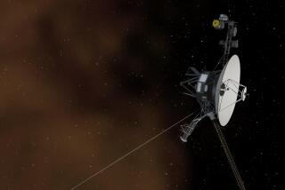
The Magellan spacecraft passed a critical milestone Saturday when it began sending back radar images of Venus and officially started its long-awaited study of the hot, cloudy planet.
“We’re into mapping,” a jubilant Tony Spears, Magellan project manager, said after receiving confirmation that the troubled craft was sending back images of the surface of Venus.
These are the first photos that Magellan has sent back since a test run before it mysteriously broke off communications with the Jet Propulsion Laboratory in Pasadena a month ago. Engineers are still puzzled over why the spacecraft twice severed its ties with Earth and went into a “safe mode” designed to facilitate recovery, but they hope to be able to complete the mission even if they never understand the nature of the earlier problems.
New commands sent up to the craft are expected to reduce the chances that it will swing its antennas away from the Earth again, but Spears said Saturday that more problems are expected.
“We could still come crashing out (of communications) like before,” Spears said. “We could from time to time come down.”
But Spears and his colleagues at the lab, which is managed by Caltech for the National Aeronautics and Space Administration, are confident that the ambitious mission is now fully under way.
“This is day 1 of 243 days (of mapping),” he said.
The sophisticated spacecraft, which is the cornerstone of a $755 million program, uses radar to pierce through the clouds that normally hide the surface of Venus. Magellan is expected to produce photos that are 10 times sharper than the best images previously available--those shot by Soviet spacecraft nearly a decade ago.
The first Magellan images, covering a strip of land 15 miles wide and 1,000 miles long, were taken before the communications problems occurred and proved that the camera is capable of living up to expectations.
Spears said the first images from Saturday’s mapping are expected to be released Monday, and that will be the best news that the troubled space agency has had in weeks. The second break could come Monday night when the space shuttle Columbia is scheduled to be launched from the Kennedy Space Center in Florida, ending a four-month grounding of the nation’s shuttle fleet caused by leaks of hydrogen fuel.
Engineers at JPL, ecstatic over their success Saturday, have been carefully analyzing data from the spacecraft for the last four weeks, trying to understand what went wrong earlier. The craft broke off communications twice, once on Aug. 16 for 14 hours and again on Aug. 21 for 17 hours.
On both occasions the craft did what it was supposed to do after an emergency: It pivoted around until it located the sun and, once it knew where the sun was, its computer told it where to find the Earth. The craft is programmed to do that so communications can be reestablished and its solar panels remain pointed toward the sun to keep its batteries charged.
During that period the craft also keeps one antenna pointed toward Earth, but that antenna is designed to cover a wide area so that it is easier for Magellan to include the Earth within its field of view. But that antenna transmits data too slowly to accomplish the goals of the mission.
Last week, engineers began putting the craft through a series of maneuvers in preparation for Saturday’s milestone. They first ordered it to begin accepting communications from the ground with an antenna that is more narrowly focused and capable of receiving more data.
Finally, on Friday they ordered it to switch to its high-speed radio link with the ground, the primary tool that will permit the craft to transmit huge volumes of data back to Earth.
That success paved the way for resuming operations, and at 9:16 a.m. Saturday the radar camera began bouncing signals off the surface of Venus.
Magellan uses radar much as a standard camera uses light to make photographs. The echo from the surface of Venus is transmitted back to Earth, where it is used to create images of the planet’s surface.
The strength of the echo tells scientists much about the topography of Venus, allowing them to distinguish between valleys and ridges, thus producing images that appear to be almost three dimensional.
Images from the first test strip, captured before the communications problems, reveal Venus to be about what scientists had expected: a planet that has been ripped and shredded by tectonic forces like those that create massive earthquakes and great volcanoes on Earth.
On Venus, the forces appear more pervasive, suggesting that nearly every region on the planet has faults that dwarf California’s legendary San Andreas Fault.
There are other scenes, even on that first test strip, that resemble many areas on Earth ranging from the deserts of Africa to the volcanoes of Hawaii.
One thing remains quite different, however. The surface of Venus is so hot that it would melt lead, and there is no vegetation, no form of life whatsoever.
That fact has long mystified scientists because in other ways Venus is so much like the Earth. It is about the same size, and about the same mass, and just a little closer to the sun.
Yet, it is so different.
Scientists hope that Magellan will help them understand why. Saturday, it began the task.


