‘Pineapple Express’ storm arrives in Southern California with even more rain expected next week

- Share via
The first of two “Pineapple Express” storms arrived in Southern California early Wednesday after delivering a stronger-than-expected pounding to Northern California, breaking rainfall records, swelling rivers and triggering landslides.
In the Sonoma County town of Forestville, a house fell into the Russian River after a rain-saturated hillside gave way. All low-lying areas of the river downstream of Healdsburg — including Guerneville — remain under evacuation orders through Thursday morning because of flooding risk, according to Sonoma County.
The storm weakened significantly as it moved down the state but another atmospheric river — of similar strength — is expected to hit the Southland on Thursday. Forecasters are predicting generally minor impacts, such as increased traffic collisions. Thursday’s rainfall in Los Angeles County is expected to be relatively light, similar to the rain that fell Tuesday night and Wednesday morning.
But still another storm, which forecasters say has the potential to be stronger, could be on the horizon for next week.
“Don’t let this week kind of lull everyone into the belief that we can handle any rain that comes,” said Ryan Kittell, a meteorologist with the National Weather Service in Oxnard. “We still have a few storms to go for the winter.”
Between Feb. 12 and Feb. 15, there’s a 20% chance of high amounts of rain — a possibility that has grown since an earlier forecast this week. There’s a 50% chance of moderate amounts of rain, a 20% chance of low amounts and a 20% chance of no rain.
The chance of high rain totals right now is “still not the most likely outcome, but enough to really keep an eye on and monitor,” Kittell said.
The storm could arrive as early as the evening of Feb. 11 or as late as the afternoon of Valentine’s Day. The duration of the rain is not yet clear. It might be steady rain that lasts six to 12 hours, or as long as one to two days, Kittell said.
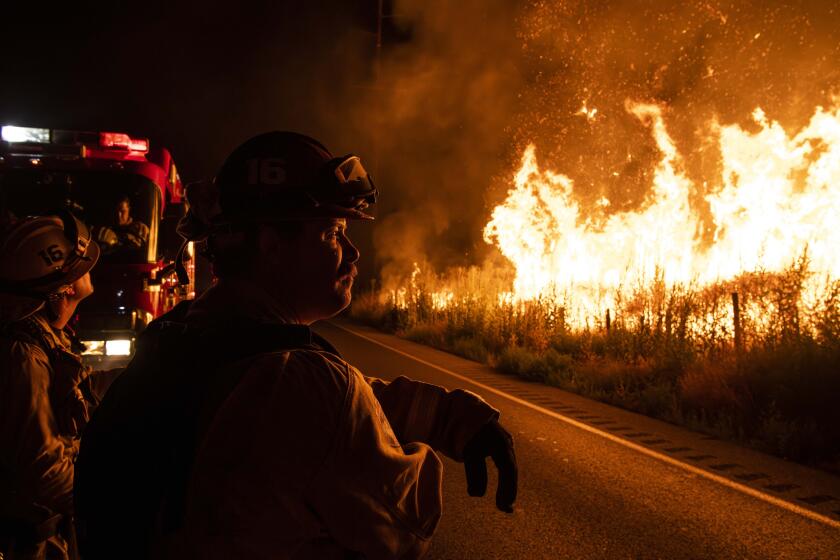
News of light rain this week was welcomed in Los Angeles County after a month of devastating wildfires that destroyed thousands of properties, including many homes, in Altadena and Pacific Palisades. The firestorms killed 29 people and were among the most destructive in California history.
While the moisture is predicted to be helpful in reducing wildfire risk across Los Angeles and Ventura counties, it likely won’t be enough to definitively end the fire season given the region’s severe winter rainfall deficit.
“Even with the rain that is expected through this week, it’s not going to be sufficient enough to completely end our fire weather season,” Kittell said. “If we get a long dry period — for a week or two or three — following the rain [later this week], then we might be back into that fire weather danger” if more Santa Ana winds return. Santa Ana wind season lasts through March.
Winds from the south and southwest, at 30 to 40 mph, will be common in L.A. and Ventura counties — and up to 50 mph in the high desert — through Friday morning. The winds could result in possible delays at Los Angeles International Airport and isolated power outages, said Kristan Lund, a meteorologist with the weather service’s Oxnard office. Gusts could be even stronger in Santa Barbara and San Luis Obispo counties, causing trees to fall.

While the storm is generally weaker than predicted across the southern portion of the state, some areas have been hit hard. About an inch and a half of rain has fallen in the Santa Ynez mountain range, and areas north of Morro Bay have seen between 2 and 5 inches of precipitation, according to the weather service.
In Southern California, officials are girding for potential landslides and mudflows in recent burn areas, though forecasters have said the risk of significant damage is low.
An 8½-mile stretch of Pacific Coast Highway — between Chautauqua Boulevard in Pacific Palisades and Carbon Beach Terrace in Malibu — remains closed because of the risk of debris flow. A four-mile stretch of Topanga Canyon Boulevard, ending at the Pacific Ocean, was also closed.
Some small businesses burned down in the Eaton fire. Others are ‘silent casualties’: Intact but out of commission as the community rebuilds.
“We have slopes — natural slopes and man-made slopes — that are quite unstable right now that could fail and have been failing even when it’s not raining,” L.A. County Public Works Director Mark Pestrella said during a news conference Wednesday. “The rain hits another level of concern for me.”
Pestrella added that “it’s the cumulative effect of these rains and not just one rainstorm” that concerns him as the communities ravaged by fire continue to rebuild.
County officials are still assessing the full scope of the damage brought by the January firestorm. The Environmental Protection Agency is currently clearing hazardous debris from burned properties including remnants of paint, batteries, oils and other potentially dangerous products. The second phase of debris removal will begin on those sites only after the EPA has removed hazardous materials, but an exact timeline hasn’t been established.
The areas hit by the fires are a high risk to nearly everyone, officials said, including motorists on roadways or residents trying to assess what’s left of their homes.
“The level of destruction and the scope of this damage is beyond anything that we have seen here in L.A. County in terms of infrastructure,” Pestrella said.
The vast majority of homes destroyed in the Eaton fire were outside of Cal Fire’s “very high” fire hazard severity zones, yet a newer approach by an independent company had found Altadena had “severe” wildfire risk.
The homes destroyed in the blazes left over 4.5 million tons of debris, nearly half of the amount of waste the county generates over the course of an entire year, Pestrella said.
Ahead of the series of storms, crews were in the fire zones installing concrete barriers, sandbags and other types of berms to filter debris and prevent it from flowing into storm drains.
Southern California won’t get too much of a break from the soggy weather before the second storm moves into the region. That storm is expected to peak in the Los Angeles area Thursday night into Friday morning.
From Friday night through Monday, there’s a potential for dry winds gusting into the region — from 15 mph to as high as 50 mph in wind-prone areas — but the risk of fire weather is minimal, given the recent precipitation, Lund said.

The week’s rainfall totals are expected to be modest.
During the first storm, preliminary rainfall totals indicate that central L.A. has received roughly one-fifth of an inch of rain; the Malibu area, about three-fifths of an inch; and southern Santa Barbara County, as much as 1½ inches.
The second atmospheric river storm is also expected to be generally light, peaking in strength between Thursday at noon to Friday at 6 a.m.
Request by the Environmental Protection Agency to process hazardous waste from the Palisades fire near Malibu City Hall faces protest.
For that second storm, Redondo Beach, Long Beach and Thousand Oaks could get about half an inch of rain; Santa Clarita and Canoga Park, three-fifths of an inch; downtown L.A., Covina and Oxnard, about three-quarters of an inch; and Santa Barbara, 1.24 inches.
“Both these storms should be very similar with similar impacts,” Kittell said.
This week’s storms are expected to be even weaker for San Diego and Orange counties and the Inland Empire.

Across Northern California, Tuesday’s atmospheric river — the second for that region since Friday — packed a punch. A gust of wind hit 90 mph in the mountains of Marin County, another was clocked at 69 mph at San Francisco International Airport, and one gust hit 55 mph in San Francisco.
A large tree branch in San Francisco’s Visitacion Valley fell and hit a person, who declined to be taken to a hospital.
Downtown San Francisco got 2.89 inches of rain Tuesday, breaking the record for the calendar day last seen in 1887, when 2.22 inches of rain was observed. San Francisco International Airport recorded 1.75 inches, breaking the record of 1.3 inches on Feb. 4, 1991.
And the Charles M. Schulz-Sonoma County Airport near Santa Rosa recorded 2.72 inches, breaking the record for the calendar day set last year, when 1.85 inches fell. Since Friday, more than 17 inches of rain have been recorded at Mt. Tamalpais in Marin County.
State Farm General asked Monday for an emergency rate increase averaging 22%, saying the Los Angeles County fires have put California’s largest insurer in dire financial straits.
Even after the rains tapered off, rivers across Northern California continued to swell.
The Russian River in Guerneville reached minor-flood stage early Wednesday, threatening homes in low-lying areas along the river, according to Sonoma County officials.
In Mendocino County, flooding occurred along California 175 at the Russian River near Hopland,the weather service office in Eureka said.
Flooding also temporarily forced the closure of some southbound lanes of Interstate 5 in Stockton. Farther north in San Joaquin County, southbound California 99 had to be shut in Lodi due to the flooding Tuesday night.
After Judy Zweig lost her home to the Palisades fire, someone stole her husband’s identity and applied fraudulently for FEMA assistance.
The back-to-back storms are bringing a fresh dose of powder to California’s northern mountain ranges.
Portions of the Sierra Nevada are expected to get a heavy accumulation of snow, up to 34 inches in some areas, and winds gusting up to 60 mph, according to the weather service.
The weather service issued a winter storm watch beginning Thursday morning and lasting through Friday morning in the Lake Tahoe area. Between 6 and 18 inches of snow are expected to fall below 7,000 feet. Elevations above 7,000 feet could see even more — between 2 to 3 feet.
In Mono County, which includes Mammoth Mountain, 1 to 2 feet of snow was expected to accumulate at elevations above 8,000 feet, and up to 6 inches below that elevation.
More to Read
Sign up for Essential California
The most important California stories and recommendations in your inbox every morning.
You may occasionally receive promotional content from the Los Angeles Times.


